3D mapping in Archaeology

And an unsolicited discussion on Virtual Archaeology

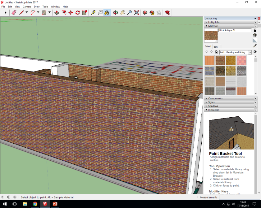
A current big focus in archaeology is video games and 3D reconstructions and environments (known as virtual archaeology) (Morgan, 2009, 471), so naturally we’ve been tasked with recreating our building (Kings Manor) in a 3D environment using a building tool called sketchup. Essentially the process involves uploading a map, and then using a tool to draw on the features which you finish by adding the right texture (one is bricks one is a photograph). The following images show my progress through the slightly finicky process:
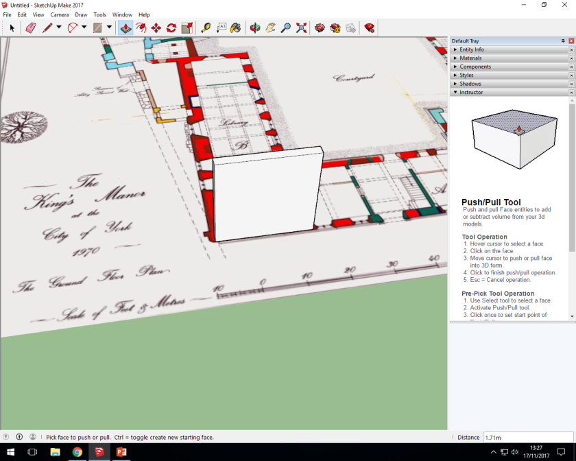
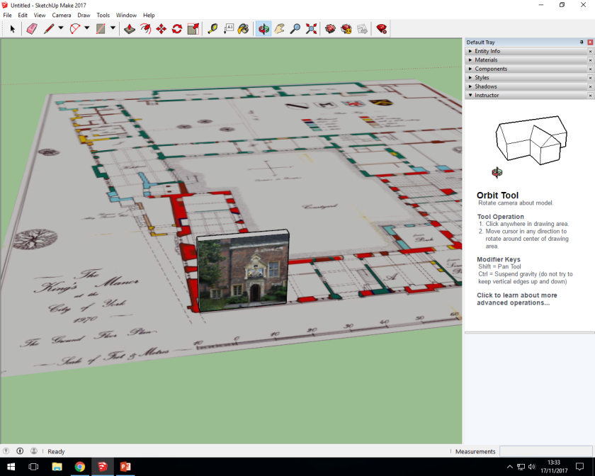
kings manor map 1kins manor map 2kinga manor map 3kings manor map 4kings manor map 5kinga manor map 6kings manor map 9kings manor map 10kings manor map 8kings manor map 11

Source: Author

I know what your thinking “wow, a door and a corridor, this is truly the best 3D reconstruction I’ve ever seen in my life” and while your assumed mental sarcasm might be right on how underwhelming my reconstruction is, 3D modelling could be a huge part of conveying information to the public through museums and online projects. Creating digital versions of archaeological sites has been the focus of quite a few projects, such as a recreation of Çatalhöyük (a neolithic site) in Second Life (Morgan, 2009) and a look into using motion capture to add humans to a 3D model of an Iron age round house (Woolford and Dunn, 2013). The Second life example is particularly interesting, as unlike most 3D modelling it is completely open to anyone with a computer and internet access, allowing things like virtual classes to take place on the recreation of the site (Morgan, 2009, 473-474), a level of freedom and openness that archaeology seems to rarely reach. Another fascinating aspect of this project was the humanity it added to the site, such as having trouble distinguishing the houses and whether or not that happened to the people that lived there (Morgan, 2009, 475), an aspect that the motion capture project also looked at, with strange issues such as when trying to map individuals sweeping them making very different movements depending whether or not they were in a reconstruction of a round house or a studio (Woolford and Dunn, 2013, 12). These aspects of Virtual archaeology are what makes it interesting, and how it can not only educate the public but also in turn inform archaeologists.

There are, however, issues with how the subject is approached and its longevity, the longevity being far more of an issue with the second life project rather than the motion capture project. It cost money to own land in Second Life (Morgan, 2009, 473) and to follow other options as buying domains, which means that when funding runs out these projects and areas can be lost forever. The problem with how Virtual archaeology is approached is a lot more subjective, especially within the realm of video games, and I personally feel archaeologists sometimes approach these projects without a proper understanding of the material. While the Çatalhöyük project understood the online world and how people interacted with it, the motion capture project had various issues such as stating that “Tools for capture and animation in video games are in
their infancy” (Woolford and Dunn, 2013, 2). This is a problem because 2 years prior L.A Noire was released, a best-selling game that was made famous by the fact that every single cut-scene in the game was motion capture- and while this may seems trivial the complete lack of knowledge about the market they were trying to break into is deeply concerning. Virtual archaeology and attempting to reach the public through the internet may be part of archaeology’s future, but understanding the virtual world needs to come first.

(Anon, ND) https://en.wikipedia.org/wiki/L.A._Noire

Morgan, C.L., 2009. (Re)Building Çatalhöyük: Changing Virtual Reality in Archaeology. Archaeologies, 5(3), pp.468–487.

Woolford, K. & Dunn, S., 2013. Experimental Archaeology and Games: Challenges of Inhabiting Virtual Heritage. Journal on Computing and Cultural Heritage, 6(4), pp.16:1–16:15.)


Licensing and Archaeology

Creative Commons License
This work is licensed under a Creative Commons Attribution-NonCommercial 4.0 International License.

Why would I need this in archaeology? Well the reality is every field has issues with legal theft of copyrighted work, not just obvious places like the music industry. I’ve chosen this particular licence because it allows people to redistribute and adapt your work as long as you are acknowledged, but nor for commercial gain. I especially chose the non commercial option because I create original artwork (such as the drawing of Augustus) and photographs, which are often stolen for things such as advertising.

Maps in Archaeology

In my communicating archaeology module we were asked to look at maps, specifically archaeological and historical maps. We were asked to look at a map archive created by the university of Edinburgh and label and annotate a map to highlight something related to our dissertation topic or an area of special interest to us. As you may have noticed from my incredibly ramble-y video that I still have no idea what my dissertation topic is going to be, so I instead decided as a starting point to look at the area around kings manor and look at any significant changes in the immediate area. What I actually found was incredibly relevant to my interests, as when you look through the different time eras of the maps something interesting happens both behind the the art gallery and between the newer headmasters building of Kings Manor.

ancient_roam

Source: Digimap

The areas I’m looking at are highlighted in purple, the first map is the 1890s.ancient_roam2

Source: Digimap

A physical connection between the newer building and the original building (Manor house- school for the blind) appears on the earliest maps after the head masters building (adjacent to King Manor) was built. This map is from the 1900’s.

ancient_roam3

Source: Digimap

This map is the most important in my opinion as it shows both the conjoining passageway from one building to another but also how far back, up until this point, the art gallery extended. This map shows the 1930’s, and the date is especially important in the context of the art gallery.

ancient_roam4

Source: Digimap

I already knew that the building behind the art gallery was gone, but I had no idea what this stage from the 1960’s was, or what the ‘Marygate education center” (barely legible on the map) was. It is interesting that Kings Manor is still listed as the “School for the blind” but also “Formerly the Kings Manor”, which is the first time on these maps the royal connection of “the Manor” is mentioned and that also this strange passageway between the two buildings still exits.

ancient_roam5

Source: Digimap

Now those smaller building behind the gallery are gone, and so is the passage way between the two buildings, which was possibly demolished when the university took over the two school buildings in the mid 60’s. The buildings behind the gallery are far more interesting in the long run, as they were demolished in 2011 and were huts for Canadian airmen in WW2- moving this into both of my passions, conflict archaeology and building archaeology. They were used as a post war school for teachers, then for both storage for the Yorkshire Museum and work rooms for art students in the 1970s, and then finally fell into disrepair by 2011 (Stead, 2011, Anon, 2013). They were demolished to make way for an open air art space, but its interesting that such a rare survival was demolished, and not only left off the gallery’s website but also completely ignored in modern tours and guides of York. It feels like a rather sad version of James Flexners ideas on archaeological maps, in that whats chosen to be recorded in maps is actually based on what the map recorder deems important, and that clearly to a decent amount of people in York these buildings didn’t really mean anything (Flexner, 2009, 17).

(Flexner, J.L. 2009. Where is reflexive map-making in archaeological research? Towards a place based approach. Archaeological Review from Cambridge, 24(1), pp.7–21.

http://www.yorkpress.co.uk/news/9363432.Demolition_of_wartime_huts_to_create_outdoor_art_area/

http://yorkstories.co.uk/buildings/history-hutments-hostel-marygate-centre/

http://digimap.edina.ac.uk/)


Video Discussion

The future of Archaeology

For part of my current course we were asked to film a 1-3 minute video concerning our choice of dissertation- I haven’t yet decided on my dissertation topic so i covered one of my ideas and it ended up longer than i wanted. I really don’t like the quality of it (I had to use the phone on my camera, on a shelf- hence the vertical filming), but I thought I’d upload it just to get used to uploading videos of my ideas onto the internet. This is a pretty good habit to get into because higher visibility equals a higher likelihood of funding, so having Youtube channels, facebook groups and blogs dedicated to archaeology is generally a good idea.

Source: Author

Now I don’t particularly like the video I’ve produced but its a very pressing matter for archaeologists to reach a younger audience, as research has shown those most likely to watch archaeological television are aged 36-55 (Bonacchi, 2013, 121).  So the most obvious choice is to reach out through the internet to a younger more mobilized audience, perhaps focusing on difference aspects of archaeology that aren’t presented in things like Time Team. A good example of this an illustration based on a paper that aimed to recreate the coat patterns of wild European horses through cave art and genetics.wild_horses_by_eurwentala-dbsmtq6

Source: Maija Karala (https://eurwentala.deviantart.com/)

This was posted to Tumblr (a social blogging site) an hour ago at the time of writing, and has subsequently gathered over 1,300 notes (individuals interacting with the post, either adding it to a list of likes, or sharing to their own page by ‘reblogging’ the post and sometimes adding their own commentary). This is significant in the way of archaeology as the majority of tumblrs user-base are under the age range of the viewership of Time Team (Mcgrath, 2016), and therefore a new generation of people who could choose to become archaeologists. A far less impressive version is my instagram, which only garners a couple of likes per post, but still shows historical and archaeological material in a way that is far more personal and therefore accessible. Showing this side of archaeology might make it more approachable and interesting to a generation that mainly associates it with much older people, clearly illustrating that there’s a place for them in archaeology.

Source: Author

This image is alongside images and videos of me camping, as well as completed and in progress pieces of art, and while this conversation has veered pretty far from video its an important part of archaeology, how to communicate ideas and how to carve a future from the next generation.

(If you’re wondering about the drawing in the video, its a stylized drawing of the statue of Emperor Augustus from Prima Porta- this is Archaeology afterall!)

(Bonacchi, C., 2013. Audiences and Experiential Values of Archaeological Television: The Case Study of Time Team. Public Archaeology, 12(2), pp.117–131.

https://blog.globalwebindex.net/chart-of-the-day/3-in-4-tumblr-users-aged-under-35/)

Archaeological Photography

An unexpected minefield

So I previously mentioned archaeological photographs- so what are they? And how are they different from normal photographs? Without further ado here are the key elements of a very thorough archaeological photograph:

  • A north arrow (as precise as possible but doesn’t need to be perfect)
  • A scale, usually in the form of a ranging rod (a pole with stripes to give scale) or a tiny scale for artifacts (with a stripe every 1 cm)
  • The site code and context, along with the date, usually all on the same board
  • And the most annoying of all- it needs to be as flat on as possible, not at an angle (or ‘oblique’) because it changes any measurements on the photo

These Here is a slightly rough-shod version of one, recording a sealed off door at Kings Manor (York):

DSC_0065

Source: Author

Now this obviously doesn’t have a site code or date, but the ranging rod and north arrow are present and the angle is as flat as possible. Archaeological photographs can also just contain a scale, and sometimes that scale can be just the presence of a human (Morgan, 2016) (Chadha, 2002, 388-389) this isn’t nearly reliable as an actual scale, but can add a human element to excavation. Compare this to a far more dynamic and interesting photograph of the same building:

DSC_0067

Source: Author

The reality is though in an archaeology report of a building or dig site this would be completely useless- how do you tell the scale of the building? Which face of the building is this? If the photo got lost would you ever be able to link it back to the investigation? It doesn’t matter that know its the entrance to the second courtyard, facing south, if none of that information is conveyed through the image. So much like archaeological drawings, photos in archaeology exist to convey as much information as possible in a single image- so they can be linked to the other information from the investigation they’re in, and also so the information can be re-used later by people from outside the investigation with as little confusion as possible. That’s not to say a perfectly executed archaeological photograph is a perfect record however, as digital photographs are surprisingly easy to lose or be corrupted, while physical black and white film photographs are surprisingly easy to maintain and archive and can therefore outlast their modern counterparts (Morgan, 2016).

That’s not to say ‘normal’ photographs have no place in archaeology- they can sometimes show aspects of a historical building or area that might not be so obvious while it’s being photographed up close. Like this (incredibly dreary) photo of the York Minster, still towering over certain parts of the city- which shows how imposing it would have been during the medieval era.church3

Source: Author

So in summary, different types of photographs fit different roles, with more strictly ‘archaeological’ ones suiting journals and books, and more aesthetically pleasing photographs acting more as an emotional connection to archaeological and historical places.

(Chadha, A., 2002. Visions of discipline: Sir Mortimer Wheeler and the archaeological method in India (1944-1948). Journal of Social Archaeology, 2, pp.378–401.

Morgan, C., 2016. Analog to Digital: Transitions in Theory and Practice in Archaeological Photography at Çatalhöyük. Internet Archaeology, (42). )

Archaeological drawing, why keep it?

Archaeological illustrations are accurately scaled outline drawings or shaded outline drawings that show 1 or more views of an artifact and that shows the specific details of the artifact, creating a standardized images more like diagrams than artwork (Adkins and Adkins, 1989, 7 and 152) but in the face of an overwhelmingly digital world its very easy to begin asking yourself why drawing is still such a big part of archaeology, especially considering the time consuming nature of doing scale drawing when compared to photographs.  In reality because of the fact that archaeological drawings are processed through a specialist before they are published means that instead of just presenting a realistic image of an object, like photography does, it actually presents an interpretation of an artifact, trench or feature. This means that not only are certain aspects of subject highlighted but the subject is made easier for others to look at and interpret- for example this practice archaeological drawing i completed of some miscellaneous glass ware (Adkins and Adkins, 1989, 7-8).

scance

Source: Author

Now this is a very rudimentary image (most archaeological drawings are neater, finished with pen and actually have site and context numbers) but it shows the scale of the item, the width, where the indents in the glass begin and end, and a clear image of the writing. This is the part that is the interpretation in drawing in archaeology- I chose the side of the glass so it was legible, I analysed the curves on the piece and decided where the began and ended, I chose a 1:1 scale. This would, when published in a journal or book, make objects easier to understand and even compare to other objects as someone with specified training has taken the time to discern the important parts of the artifact. When this is compared to a standard photograph (archaeological photographs are more specific and will be covered in the next post) you can tell how many details and specifics are made clear by the illustration. Photographs are used in publications, but usually alongside drawings to give a more in depth understanding of the subject at hand rather than to replace drawings.

20171013_134331

Source: Author

I deliberately chose glass because it would prove a more succinct point about interpretation than, say, a decorated pot which might be very easy for anyone let alone an archaeologist to look at and get a decent ‘feel’ of the object. In real archaeology most objects are chosen to be illustrated for use in publications such as journals and books, but can also be undertaken for comparative studies or for archiving use- as at their core archaeological illustrations exist to convey as much information as possible in the most condensed space (Adkins and Adkins, 1989, 9).

And no I don’t know what Indian sauce is either.

(Adkins, L. and Adkins, R. 1989. Archaeological illustration, Cambridge; New York: Cambridge University Press.)